
vue高德地图绘制行政区边界功能
更新时间:2024年03月12日 10:43:02 作者:zj_zjk_sjz
这篇文章主要介绍了vue高德地图绘制行政区边界功能,本文通过实例代码给大家介绍的非常详细,感兴趣的朋友一起看看吧
vue高德地图绘制行政区边界
<template>
    <div id="gaodeMap"></div>
</template>
<script>
    import AMapLoader from "@amap/amap-jsapi-loader";
    // 设置安全密钥
    window._AMapSecurityConfig = {
        securityJsCode: '从高德申请的安全密钥',
    }
    export default {
        name: "index",
        data() {
            return {
                districtCode:'310112',
                district: null,
                polygons : [],
                //行政区划查询
                opts: {
                    subdistrict: 0,   //获取边界不需要返回下级行政区
                    extensions: 'all',  //返回行政区边界坐标组等具体信息
                    level: 'district'  //查询行政级别为 区
                }
            }
        },
        mounted() {
            this.getMapCenter();
            this.initMap();
        },
        methods: {
            getMapCenter() {
                this.districtCode = this.$route.params.districtCode
            },
            /**
             * 初始化地图
             */
            initMap() {
                AMapLoader.load({
                    key: "从高德申请的key",
                    version: "2.0",
                    plugins: ['AMap.Scale', 'AMap.DistrictSearch'],
                }).then((AMap) => {
                    // 初始化地图
                    this.map = new AMap.Map('gaodeMap', {
                        viewMode: "2D",
                        resizeEnable: true,
                        center: [116.30946, 39.937629],
                        zoom: 3
                    });
                    this.map.addControl(new AMap.Scale())
                    this.drawBounds();
                }).catch(e => {
                    console.log(e);
                });
            },
            /**
             * 绘制区域
             */
            drawBounds() {
                let that = this
                this.district = new AMap.DistrictSearch(this.opts)
                this.district.search(this.districtCode, function (status, result) {
                    that.map.remove(that.polygons)//清除上次结果
                    that.polygons = [];
                    let bounds = result.districtList[0].boundaries;
                    if (bounds) {
                        for (let i = 0, l = bounds.length; i < l; i++) {
                            //生成行政区划polygon
                            let polygon = new AMap.Polygon({
                                strokeWeight: 1,
                                path: bounds[i],
                                fillOpacity: 0.4,
                                fillColor: '#80d8ff',
                                strokeColor: '#0091ea'
                            });
                            that.polygons.push(polygon);
                        }
                    }
                    that.map.add(that.polygons)
                    that.map.setFitView(that.polygons);//视口自适应
                });
            }
        }
    }
</script>
<style scoped>
    #gaodeMap {
        width: 100%;
        height: 100%;
    }
</style>
补充:
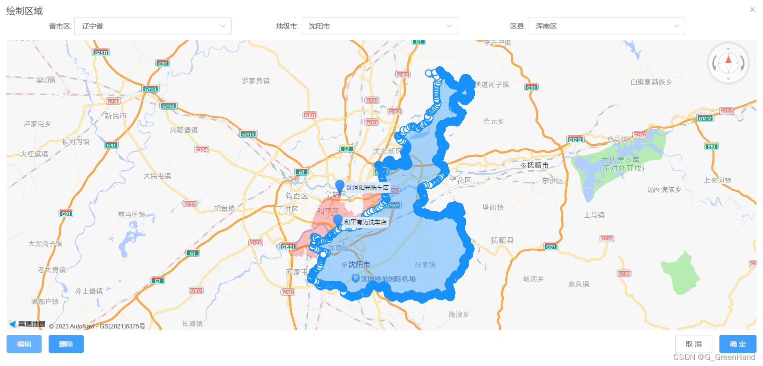
vue 实现 高德地图绘制并编辑区域功能
业务需要参考很多文章最后实现的功能 仍有缺陷 先展示
1.根据所在区域自动绘制范围
2.切换区域自动切换所画范围
3.回显其他人绘制的范围(业务需求绘制范围不可以重复)
4.绘制的区域可编辑 可删除
(删除功能仍有瑕疵 实现了部分删除功能 都是比较傻瓜试的操作 不喜勿喷)

编辑的时候白色点是可以取消掉的
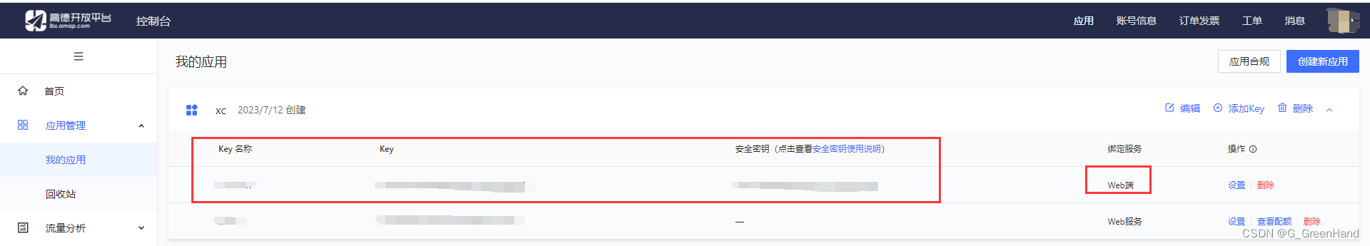
高德地图开放平台https://lbs.amap.com/api/javascript-api-v2/summary/
要在控制台见一个key才可以运行高德地图插件 要选web服务的才行
下载插件
npm i @amap/amap-jsapi-loader --save
上代码
我的是弹窗的形式 主页面
<el-dialog
        title="绘制区域"
        width="80%"
        top="8vh"
        :visible.sync="dialogVisible"
        :before-close="hideDialog"
        :close-on-click-modal="false"
        class="dialogPa"
      >
        <div class="dialog-body" >
        //centerDrop: [123.455551,41.798729]地图中心点 allCoordinates其他人绘制的区域数据 address当前区域文字areaCode当前区域code isUpdateBtn是否显示编辑按钮 updateId可修改数据的id  isaddBtn是否是新增 mapIdDiv地图画布id
          <seeAddIndex v-if="dialogVisible" :center="centerDrop"  :allCoordinates="alllist"  :address="dataForm.address" :areaCode="dataForm.areaCode"  :isUpdateBtn="true"  @mapList="mapList"  :updateId="updateId"  :isaddBtn="isaddBtnMap"  :mapIdDiv="'mapIdDiv'+updateId"></seeAddIndex>
        </div>
      </el-dialog>
js部分
import seeAddIndex from "@/components/AMapLoader/seeAddIndex.vue"; //自定义高德地图绘制区域
 components: {seeAddIndex },
 //组件点击确定或取消 istype确定/取消  date点集合数据 mapname切换后的区域数据
  mapList(istype,date,mapname) {
      var that = this;
      if(istype){// 确定
        that.newlatlng = date;
      console.log("---", date);
      //...调用保存接口
      }else{//取消
        that.newlatlng = [];
        that.dialogVisible = false;
      }
    }
组件代码
<template>
  <div class="container">
    <div class="input-card mapNewCss">
      <div class="input-item">
        <div class="input-item-prepend">
          <span class="input-item-text">省市区:</span>
        </div>
        <el-select
          style="width: 70%;"
          v-model="province"
          @change="searchNew('province')"
        >
          <el-option
            v-for="item in provinceList"
            :key="item.adcode"
            :label="item.name"
            :value="item.adcode"
            @click.native="getName('province',item)"
          >
          </el-option>
        </el-select>
      </div>
      <div class="input-item">
        <div class="input-item-prepend">
          <span class="input-item-text">地级市:</span>
        </div>
        <el-select
          style="width: 70%;"
          v-model="city"
          @change="searchNew('city')"
        >
          <el-option
            v-for="item in cityList"
            :key="item.adcode"
            :label="item.name"
            :value="item.adcode"
            @click.native="getName('city',item)"
          >
          </el-option>
        </el-select>
      </div>
      <div class="input-item">
        <div class="input-item-prepend">
          <span class="input-item-text">区县:</span>
        </div>
        <el-select
          style="width: 70%;"
          v-model="district2"
          @change="searchNew('district')"
        >
          <el-option
            v-for="item in districtList"
            :key="item.adcode"
            :label="item.name"
            :value="item.adcode"
            @click.native="getName('district2',item)"
          >
          </el-option>
        </el-select>
      </div>
    </div>
    <div :id="mapIdDiv" style="width: 100%;height: 65vh;"></div>
   //两个编辑方法 一个是新增的编辑  一个是修改的编辑 获取到的绘制区域图层不一样 数据格式对不上就不会显示 所以就很笨拙的实现基本功能  希望有大神可以优化
    <div class="input-card">
      <el-button v-if="isaddBtnOne"
      class="filter-item"
      type="primary"
      @click="upPolygon"
      :disabled="isDisabled"
      >编辑</el-button
    >
      <el-button
        v-if="!isaddBtnOne"
        class="filter-item"
        type="primary"
        @click="getPoly"
        :disabled="isDisabled"
        >编辑</el-button
      >
//删除功能部分数据实现了
      <el-button
        v-if="isClear"
        class="filter-item"
        type="primary"
        @click="clearPolygon"
        :disabled="isDisabled"
        >删除</el-button
      >
      <div style="float: right;" v-if="isUpdateBtn">
        <el-button @click="hideDialog">取 消</el-button>
        <el-button type="primary" @click="getOk"  :disabled="isDisabled">确 定</el-button>
      </div>
    </div>
  </div>
</template>
<script>
import AMapLoader from "@amap/amap-jsapi-loader";
export default {
  name: "AreaMapSee",
  props: {
    //地图id
    mapIdDiv: {
      type: '',
      default: 'container'
    },
    //中心点
    center: {
      type: '',
      default: null
    },
      //所有数据
    allCoordinates:{
    type: '',
    default: null
    },
     //回显区域数据
    //  coordinates: {
    //   type: Object / Array,
    //   default: []
    // },
    address:{
      type: "",
      default: null
    },
    areaCode:{
      type: "",
      default: null
    },
        //编辑按钮
    isUpdateBtn: {
      type: Boolean,
      default: false
    },
    //待修改的id
    updateId: {
      type: '',
      default: null
    },
     // 新增按钮
     isaddBtn: {
      type: Boolean,
      default: false
    },
  },
  data() {
    return {
      map: null,
      polyEditor: null,
      polyEditorNew: null,
      addNumber:0,
      updatePolygon:null,
      updateCoordinates:[],
      isaddBtnOne: false,
      isDisabled: false,
      district: null,
      polygonArea: [],
      serviceList: [],
      province: "",
      provinceName:'',
      provinceList: [],
      city: "",
      cityName: "",
      cityList: [],
      district2: "",
      district2Name: "",
      districtList: [],
      street: "",
      streetList: [],
      addOne:false,
      mapSeeA:0,//第一次进入页面
      mapAreaCode:'',
      mapAreaName:'',
      newMap:false,
      isClear:true,
    };
  },
  mounted() {
    console.log("mounted",this.address,this.areaCode);
    //对当时接口返回参数的处理
    if (this.address) {
        let address = this.address.split(",");
        this.province=address[0]
        this.provinceName=address[0]
        this.city=address[1]
        this.cityName=address[1]
        this.district2=address[2]
        this.district2Name=address[2]
        this.mapAreaCode=this.areaCode
      }
    this.isaddBtnOne = this.isaddBtn;
    this.echart();
  },
  methods: {
    echart() {
      let that=this
      AMapLoader.reset()
      AMapLoader.load({
        key: "", // 申请好的Web端开发者Key,首次调用 load 时必填
        version: "2.0", // 指定要加载的 JSAPI 的版本,缺省时默认为 1.4.15
        plugins: [
          "AMap.ToolBar",
          "AMap.Driving",
          "AMap.PolygonEditor",
          "AMap.PlaceSearch",
          "AMap.ControlBar",
          "AMap.Scale",
          "AMap.Geocoder",
          "AMap.DistrictSearch"//区域查询
        ], // 需要使用的的插件列表,如比例尺'AMap.Scale'等
      })
        .then((AMap) => {
          that.map = new AMap.Map(that.mapIdDiv, {
            resizeEnable: true,
            // viewMode: '3D',
            pitch: 45,
            zoom: 13, // 初始化地图级别
            center:that.center, // 初始化地图中心点位置
          });
          const ControlBar = new AMap.ControlBar({
            position: { top: '0', right: '10px' }
          })
          that.map.addControl(ControlBar);
    //       //数据格式化;
          let allList=that.allCoordinates//列表所有数据
          let data=[]
          for (var i = 0; i < allList.length; i++) {
              if (allList[i].serviceRange) {
                let data2 = JSON.parse(allList[i].serviceRange);
                if(data2.coordinates[0]){
                  let list=data2.coordinates[0]
                  if(allList[i].id!=that.updateId){
                    console.log('allList[i].id',allList[i].id,that.updateId)
                    data.push({list:list,name:allList[i].name,id:allList[i].id})
                    // data.push(list)
                    }else{
                    //可编辑数据
                      console.log('that.updateId',that.updateId)
                      that.updateCoordinates={list:list,name:allList[i].name,id:allList[i].id}
                    }
                  }
                }
              }
          console.log('data',data)
          let lengthaaa=data.length
          that.polygonList=[]
          for (var j = 0; j < data.length; j++) {
              var points
              var name
              //循环遍历添加多边形;
                points = data[j].list;
                name=data[j].name
                let polygon1 = new AMap.Polygon({
                  path: points,
                  strokeColor: "#FF0000",
                  strokeWeight: 1,
                  strokeOpacity: 0.2,
                  fillOpacity: 0.24,
                  fillColor: "#FF0000",
                  zIndex: 20,
                });
                that.polygonList.push(polygon1);
                that.map.add([polygon1]);
                let marker = new AMap.Marker({
                position: points[0],
                offset: new AMap.Pixel(0, 0),
                direction:'right',
              })
                marker.setLabel({
                position: points[0],
                icon: "//a.amap.com/jsapi_demos/static/demo-center/icons/poi-marker-default.png",
                direction:'right',
                offset: new AMap.Pixel(0, 0),  //设置文本标注偏移量
                content: "<div style='background-color: #D9EAFF;color:#333;padding:3px;'>"+name+"</div>", //设置文本标注内容
              });
              that.map.add(marker)
          }
          //可编辑数据
          that.updatePolygon = new AMap.Polygon({
            path: that.updateCoordinates.list,
            strokeColor: "#0075FF",
            strokeWeight: 1,
            strokeOpacity: 0.2,
            fillOpacity: 0.24,
            fillColor: "#0075FF",
            zIndex: 20,
            extData:{
              id:that.updateCoordinates.id
            }
          });
          that.polygonList.push(that.updatePolygon);
          that.map.add([that.updatePolygon]);
          that.map.setFitView();
          that.polyEditor = new AMap.PolygonEditor(that.map,that.updatePolygon);//编辑数据
              //行政区划查询
              var opts = {
            subdistrict: 1, //返回下一级行政区
            showbiz: false //最后一级返回街道信息
          };
          that.district = new AMap.DistrictSearch(opts);
          that.district.search("中国", function(status, result) {
            if (status == "complete") {
              that.getData(result.districtList[0], "province");
              that.searchNew("province","no",1); //默认城市
            }
          });
        })
        .catch((e) => {
          console.log("---",e);
        });
    },
      //删除当前编辑区域
      clearPolygon(){
      let that=this
      that.polyEditor.close()
      if(that.isaddBtnOne){//新增
        let polygonDiv = that.map.getAllOverlays("polygon"); //获取所有的polygon
        let number=polygonDiv.length
        console.log('polygonDiv',polygonDiv)
        that.map.remove(polygonDiv[number-1])	// 移除覆盖物
      }else{//编辑
        let overlaysList=that.polygonList
        for(var i = 0; i < overlaysList.length; i++){
            // 获取存在每个 extData 中的 id
            var id = overlaysList[i].getExtData().id;
            console.log('that.updateId',that.updateId)
                if(id === that.updateCoordinates.id){//可编辑的id区域
                that.map.remove(overlaysList[i])	// 移除覆盖物
                  console.log('id',id)
                  break;
                }
            }
      }
      that.isClear=false
      that.isDisabled=true
    },
    getPoly() {
      this.polyEditor.open();
    },
    showInfoClick(e) {
      console.log("**", e.lnglat.getLng() + "," + e.lnglat.getLat());
      this.isDisabled = false;
    },
    getOk(){
      let overlaysList = this.map.getAllOverlays('polygon'); //获取所有的polygon
      let pathList=[]
      for(let i=0;i<overlaysList.length;i++){
      let path=overlaysList[i]._opts.path
      if(path&&path.length>0){
          pathList.push(path)
        }
      };
      let number=pathList.length
      console.log('==all',pathList)
      var mapname={
        provinceName:this.provinceName,
        cityName:this.cityName,
        district2Name:this.district2Name,
        mapAreaCode:this.mapAreaCode
      }
      console.log("mapname",mapname)
      if(this.newMap||this.isaddBtn){//新增
        console.log('==2',[pathList[number-1]])
        this.$emit("mapList",true,[pathList[number-1]],mapname);
      }else{//编辑
        console.log('==1',[pathList[number-2]])
        this.$emit("mapList",true,[pathList[number-2]],mapname);
      }
    },
    hideDialog() {
      this.$emit("mapList", false);
    },
    getData(data, level,numbera) {
      var that = this;
      var bounds = data.boundaries;
      console.log("bounds", bounds);
      if (bounds) {
        for (var i = 0, l = bounds.length; i < l; i++) {
          var polygon = new AMap.Polygon({
            map: that.map,
            strokeWeight: 1,
            strokeColor: "#0091ea",
            fillColor: "#80d8ff",
            fillOpacity: 0.2,
            path: bounds[i]
          });
          that.polygonArea.push(polygon);
        }
        that.map.setFitView(); //地图自适应
      }
      console.log(numbera,'that.polygonArea',that.polygonArea)
      let newList=that.polygonArea
      let polygonAreaList=[]
      var subList = data.districtList;
      if (subList) {
        if (level === "province") {
          that.provinceList = subList;
        } else if (level === "city") {
          that.cityList = subList;
        } else if (level === "district") {
          that.districtList = subList;
          console.log('that.districtList',that.districtList)
        } else if (level === "street") {
          for (var i = 0, l = subList.length; i < l; i++) {
            subList[i].adcodeKey = i + "key" + subList[i].adcode;
          }
          that.streetList = subList;
          console.log('that.streetList')
          that.isDisabled=false
          console.log('that.isDisabled',that.isDisabled)
        }
        console.log("curList", level, subList);
        if(that.mapSeeA==0){
          that.setCenter(that.center);
          that.mapSeeA++
        }
      }
      if(numbera==1){
        that.searchNew("city","no",2); //默认城市
      }else if(numbera==2){
        that.district2=that.areaCode
        that.searchNew("district","no",3); //默认城市
      }
    },
    getName(type,data){
      var that=this
      if(type=='province'){
        that.provinceName=data.name
      }
      if(type=='city'){
        that.cityName=data.name
      }
      if(type=='district2'){
        that.isaddBtnOne=true
        that.newMap=true
        that.district2Name=data.name
      }
    },
    //选择type no不清空加载默认数据
    searchNew(type,clearType,numbera) {
      var that = this;
      that.polyEditor.close();
      that.$forceUpdate();
      //清除地图上所有覆盖物
      for (var i = 0, l = that.polygonArea.length; i < l; i++) {
        that.polygonArea[i].setMap(null);
      }
      var adcode = "";
      var typeNext = "";
      if (type == "province") {
        adcode = that.province;
        typeNext = "city";
        //清空下一级别的下拉列表
        if(clearType!='no'){
          that.city = "";
          that.cityList = [];
          that.district2 = "";
          that.districtList = [];
        }
      }
      if (type == "city") {
        adcode = that.city;
        typeNext = "district";
        //清空下一级别的下拉列表
        if(clearType!='no'){
          that.district2 = "";
          that.districtList = [];
        }
      }
      if (type == "district") {
        adcode = that.district2;
        typeNext = "street";
      }
      that.district.setLevel(type); //行政区级别
      that.district.setExtensions("all");
      //行政区查询
      //按照adcode进行查询可以保证数据返回的唯一性
      this.mapAreaCode=adcode
      console.log('this.mapAreaCode',this.mapAreaCode)
      that.district.search(adcode, function(status, result) {
        if (status === "complete") {
          that.getData(result.districtList[0], typeNext,numbera);
        }
      });
    },
    setCenter(obj) {
      this.map.setCenter(obj);
      console.log('obj',obj)
    },
    upPolygon(){
      let that=this
      let overlaysList = this.map.getAllOverlays('polygon'); //获取所有的polygon
      let pathList=[]
      for(let i=0;i<overlaysList.length;i++){
      let path=overlaysList[i]._opts.path
      if(path&&path.length>0){
          pathList.push(path)
        }
      };
      let number=pathList.length
      console.log('==all',pathList)
      console.log('==ADD',[pathList[number-1]])
      var pathLista=[pathList[number-1]]
       //可编辑数据
       that.updatePolygon = new AMap.Polygon({
            path: pathLista,
            strokeColor: "#0075FF",
            strokeWeight: 1,
            strokeOpacity: 0.2,
            fillOpacity: 0.24,
            fillColor: "#0075FF",
            zIndex: 20,
            extData:{
              id:''
            }
          });
          that.polygonList.push(that.updatePolygon);
          that.map.add([that.updatePolygon]);
          that.map.setFitView();
          that.polyEditor = new AMap.PolygonEditor(that.map,that.updatePolygon);//编辑数据
          that.polyEditor.open();
    },
    //编辑区域数据
    upPolygon2(){
      var that=this
      let polygonAreaList=[]
      let newList=that.polygonArea
      console.log('this.polygonArea',that.polygonArea)
      for (var j = 0; j < newList.length; j++){
        //可编辑数据
        let path=newList[j]._opts.path
      let updatePolygon = new AMap.Polygon({
            path:path,
            strokeColor: "#0075FF",
            strokeWeight: 1,
            strokeOpacity: 0.2,
            fillOpacity: 0.24,
            fillColor: "#0075FF",
            zIndex: 20,
          });
      polygonAreaList.push(updatePolygon)
       that.map.add([updatePolygon]);
      }
      console.log('polygonAreaList',polygonAreaList)
      //可编辑数据
      // that.updatePolygon = new AMap.Polygon({
      //       path: that.updateCoordinates.list,
      //       strokeColor: "#0075FF",
      //       strokeWeight: 1,
      //       strokeOpacity: 0.2,
      //       fillOpacity: 0.24,
      //       fillColor: "#0075FF",
      //       zIndex: 20,
      //       extData:{
      //         id:that.updateCoordinates.id
      //       }
      //     });
          // that.polygonList.push(that.updatePolygon);
          // that.map.add([that.updatePolygon]);
      that.polyEditorNew = new AMap.PolygonEditor(that.map,polygonAreaList);//编辑数据
      that.polyEditorNew.open();
      // that.polyEditorNew.close();
      // this.polyEditorNew.setTarget();
      // this.polyEditorNew.open();
      }
  },
};
</script>
<style lang="scss" scoped>
.input-card{
  margin-top: 10px;
}
/deep/ .amap-marker-label{
  border: 1px solid #D9EAFF;
  padding: 0;
  border-radius: 6px;
}
.cityListCss {
  display: inline-block;
  min-width: 50px;
  color: #333;
  cursor: pointer;
  padding: 4px 10px;
}
.activeCss {
  color: #1d6bff;
}
/* 行政查询样式 */
.mapNewCss{
  margin-top: -40px !important;
  margin-bottom: 10px;
}
.mapNewCss .input-item {
  display: inline-block;
  width: 30%;
  text-align: right;
}
.mapNewCss .input-item .input-item-text{
  display: inline-block;
  text-align: right;
}
.mapNewCss .input-item .input-item-prepend {
  display: inline-block;
  width: 20%;
}
</style>
到此这篇关于vue高德地图绘制行政区边界的文章就介绍到这了,更多相关vue高德地图绘制内容请搜索脚本之家以前的文章或继续浏览下面的相关文章希望大家以后多多支持脚本之家!
相关文章
 这篇文章主要为大家详细介绍了基于vuejs实现一个todolist项目,具有一定的参考价值,感兴趣的小伙伴们可以参考一下2017-04-04
 这篇文章主要介绍了electron vue 模仿qq登录界面,首先使用vuecli创建vue项目,安装electron,本文通过示例代码给大家介绍的非常详细,对大家的学习或工作具有一定的参考借鉴价值,需要的朋友可以参考下2022-08-08
 做公司官网项目的时候遇到的场景,顶部导航栏分类商品跳转到分类详情,然后在分类详情再次点击顶部导航栏里另外的分类商品,跳到同样的页面数据不刷新,下面小编给大家分享解决方式,关于vue跳转不刷新问题感兴趣的朋友一起看看吧2023-09-09
 下面小编就为大家带来一篇Vue内容分发slot(全面解析)。小编觉得挺不错的,现在就分享给大家,也给大家做个参考。一起跟随小编过来看看吧2017-08-08
 这篇文章主要为大家详细介绍了Vue小组件BootPage实现简单的分页功能,文中示例代码介绍的非常详细,具有一定的参考价值,感兴趣的小伙伴们可以参考一下2016-09-09
 在本篇文章里我们给大家整理的是关于vue指令v-html使用过滤器filters功能的实例内容,需要的朋友们学习下。2019-10-10
 这篇文章主要介绍了Vue中的同步和异步调用顺序,具有很好的参考价值,希望对大家有所帮助。如有错误或未考虑完全的地方,望不吝赐教2022-01-01
 本文主要介绍了vue3+ts代理的使用,文中通过示例代码介绍的非常详细,对大家的学习或者工作具有一定的参考学习价值,需要的朋友们下面随着小编来一起学习学习吧2023-12-12
 这篇文章主要介绍了Vue数据更新视图不更新的几种解决方案小结,具有很好的参考价值,希望对大家有所帮助。如有错误或未考虑完全的地方,望不吝赐教2022-08-08
 本篇文章给大家总结了Visual Studio Code断点调试Vue的方法以及心得分享,需要的朋友参考学习下。2018-02-02


最新评论